|
NextGen Day - Philippine Travel - Batangas Guide and Travel Information |
|
BATANGAS TRAVEL INFORMATIONWhere to Stay in Batangas |
History | Distance
Batangas was founded in 1581. Originally, it was composed of the present provinces of Batangas, Mindoro, Marinduque, Southeast of Laguna and even far Camarines. After several devastating eruptions of Taal Volcano, the smallest volcano in the world, the old Taal town site was buried. The capital was eventually transferred to Batangas (now a city) in 1754 where it has remained to date. The name "Batangas" was derived from the word "batang," which is a term of the natives for the numerous logs found in the Calumpang River, the body of water that runs through the northeastern portion of the town and assumes the shape of a tuning fork. Batangas was also among the first of the eight Philippine provinces to revolt against Spain and also one of the provinces placed under Martial Law by Spanish Governor General Ramon Blanco on August 30, 1896. During the Spanish-American War, many outstanding Batangueños made names in our history. Most notable of them are Apolinario Mabini, also known as the sublime paralytic and "Brains of the Revolution"; Marcela Agoncillo who made the present Philippine flag, and General Miguel Malvar who was recognized as the last Filipino general to surrender to the Americans. For this, Batangas also came to be known as the "cradle of heroes and nationalists." Batangas is the home of sages and the birthplace of the country´s notable nationalists. Historical places have been the legacy of the old eras. Natural resources and picturesque views abound in the area. Numerous fine beaches have been the sought-after-sites. And a few kilometers away from the shore will bring the more adventurous ones to diverse dive sites, from the ones fit for a novice (relatively shallow, constant water current), up to the ones for those who may call themselves experts. The proximity of Batangas to Manila and the good quality of most of the main provincial roads are advantageous for the existing attractions and facilities of the province. The tourism industry has been regarded as a contributor to the economy of the province.
In 1534, Batangas became the first practically organized province in Luzon. Balayan was the capital of the province for 135 years from 1597-1732. In 1732, it was moved to Taal, then the flourishing and most progressive town in the province. Batangas was also one of the few provinces in the country which can boast of having a distinctive culture of its own. The song and dance repertoire called "kumintang" is of Batangas origin. Because of this, it came to be known as "La Provincia del Cumintang". Batangas International Port ------------------ 20 min. Dry Season from November to April and wet season for the rest of the year which is favorable to agriculture and industries. Batangas has a natural cool climate. It experiences two types of seasons: dry from November to April and wet for the rest of the year. Mean annual rainful is at maximum during July at 1.5 to 2.5 meters. March is the driest month. Mean monthly temperature is 82 degrees Fahrenheit. February is the coldest month averaging 69 degrees Fahrenheit while May is the hottest at 96.1 degrees Fahrenheit. Lipa City and Mataas na kahoy enjoying the coolest temperatures. Power: National Power Corporation through Manila Electric Company The terrain of the province is generally rolling. Fifty percent of its land area has a grade of less than 15 degrees. The rest are mountainous and hilly.
Submarine Garden. Also located in the town of Lobo. The garden consists of living corals near the shore and is one of the beaches of Lobo. It can be clearly seen during the early mornings when the water is clear and the tide is low. Mahabang Buhangin Beach. Located in the town of San Juan, the area has white sand and a living colony of corals. It lies in a cave that is a prerequisite for a fine beach. A cave nearby adds to the attraction of the beach. Hugon Beach. Located in Barangay Hugon, San Juan. The sand in Hugon Beach is white and is more than one kilometer long. Some parts of the sea bottom are covered with smooth rocks although the bottom is predominantly sandy. There is a sudden drop-off only about ten meters from the beach. Aqua sports, such as snorkeling and swimming are recommended. Tingga Falls. Located in Daang Ibaan, Batangas City. The falls is about 30ft. high with a pool made into a swimming area at its base. It is semi-developed with concrete steps built for access. Munting Buhangin Beach. Located in Nasugbu. The area is located
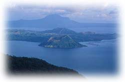
in a cove and offers a fine, white sand beach. Taal Lake and Volcano. Fresh water beach, also known as the lowest volcano in the world. Surrounded by a lake, the volcano is situated on an 8.8 Km. isled lapped by the 27 km long lake. Both the lake and the volcano are situated on the crater of an extinct volcano. The Volcano Island is also ideal for trekking. The volcano is the smallest in the world. The lake holds four interesting features: two smaller lakes of hot water, one green and the other almost red: a gas vent; and a triangular obelisk of hard rock. It is a focal point of the province! A must see!! Matabungkay Beach. A two-kilometer long white sand beach situated in the town of Lian facing the China Sea. The area is ideal for water sports such as swimming, boating, yachting, fishing and skin diving. Dotting the shoreline are several summer cottages. Mt. Maculot. Located in Cuenca . One of the highest and prominent mountains in the province, it is one of the favorite sites of mountain trekkers. It is said that the mountain was the last stronghold of the Japanese in the province before they were defeated. Several tunnels built by the Japanese soldiers still exist in the area. The name Mt. Maculot was derived from the people who lived in the mountain whose hairs are kinky. Calijon Falls. Located in Barangay Calijon, Malvar. The attraction consists of two major falls and two smaller ones. One of the bigger falls is about ten feet high with a great volume clear water gushing down to a shallow pool, while the other one (also about ten feet high) braces the rock where the water flows look like a bridal gown. One of the two smaller falls is located in front of a cave, while the other one forms a series of small cascades. All the falls are located in an area of about 300 sq. meters. Mainit Hot Spring. Located in Baronage Pulang Bato, San Juan . About 10 km south of San Juan, it is ideally located at the foot of a huge mountain lush with thick vegetation. Tinalunan. Also located on the Island of Isla Verde . This is a spot where wind-tossed waves surge and beat against the rocky cliff supporting a long plateau. From atop the plateau, one commands a scenic sight specially when the sea is calm. Cueva Sitio. Also located on the island of Isla Verde. An ideal place for picnics. Its main attraction is a rockshelter that has always provided cool shade to the visitors. Ilijan Falls. Located in Barangay Ilijan. A unique waterfall with water coming from a big spring at the top of a mountain, gracefully from one bowl to another. It has seven huge stone bowls carved naturally out of the mountainsides and beautifully arranged like a flight of stairs. Sepok Point. Located on the southwestern part of Maricaban Island, it has white sands and shaped like a cove. Bulalacao Falls. Located in Barangay Bulaklakan, Lipa City. The area has about three small falls and enclosed in a canyon, the highest is about ten feet high with the water com. Where to Stay in Batangas |
History | Distance |
Philippine Infrastructure - Philippine Sports & Recreations - Philippine Travel Tips
Getting Around to the Philippines - Philippine Map
People of the Philippines - Culture and Arts - Philippine Religion - Philippine Churches
Philippine Food & Cuisine - Philippine Festivals and Events - Philippine Beaches
Philippine Dive - Philippine Wildlife - Philippine Heritage Sites - Philippine Golf - Philippine Popular Activities
NextGen Day
Hotels | Cruises | Flights | Travel Agents | Tour Operators | Travel and Leisure
Travel Incentive Program / Travel Articles / Travel Recreation & Activities
Travel Updates / Health Tourism / Real Estate Tourism
NextGen Day : Australia, Asia Travel, Africa Travel, Europe Travel, Middle East Travel, USA Travel
 In
1570, Martin de Goiti and Juan de Salcedo, two Spanish generals explored
the coast of Batangas on their way to Manila and came upon a Malay sttlement
at the mouth of Taal River. In 1572, the town of Taal was founded and
its convent and stone church were constructed later.
 Batangas
first came to be known as Bonbon. It was named after the mystical and
fascinating Taal Lake, which was also originally called Bonbon. Some
of the earliest settlements in Batangas were established at the vicinity
of Taal Lake.
 Gerthel
Beach. Located in the town of Lobo, it is one of the finest beaches
of the area. The approximately one kilometer stretch of white sand beach
has gradually sloping ocean floor to about two hundred meters before
the drop-off. A beach resort that also serves as an accommodation facility
also exists.