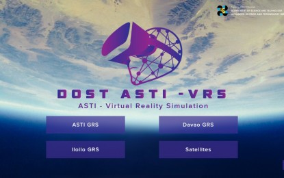
ASTI has developed an app that allows the general people to have a glimpse into space.
The Advanced Science and Technology Institute (ASTI) released the free virtual reality simulation (VRS) software on the Google Play Store on August 25, 2021, with the aim of providing a glimpse into space.
A complete computer-generated simulation of ASTI’s ground receiving stations (GRS) in Metro Manila, Davao City, and Iloilo is included in the DOST-ASTI VRS software. It also has a satellite showcase, where viewers may learn about the Diwata and Maya satellites, as well as the commercial satellites that the Philippine Earth Data Resource and Observation (PEDRO) Center subscribes to.
Because facility visits are not possible due to the coronavirus disease 2019 (Covid-19) pandemic, the app development would allow the public to still visit the GRS.
“This is our imaginative way of bringing space closer to Filipinos. Using the app, they will be able to examine the three GRS as well as the locally-made satellites “During the launch, Secretary of the Department of Science and Technology (DOST) Fortunato de la Pea remarked.
He went on to say that the app would provide people a better understanding of the possibilities of space technology.
“We believe that this will help increase public awareness and encourage everyone, particularly the young, to get interested in space science research and develop a respect for it,” he added.
A 3.7-meter earth observation (EO) satellite tracking antenna is housed in the country’s first GRS in Quezon City. A 7.3-meter EO satellite tracking antenna is housed in the second GRS, which was inaugurated in Davao City in 2019. According to ASTI, the one in Iloilo City is currently under construction and will contain a 3.5-meter EO satellite tracking antenna.
The software also shows how the PEDRO Center operates, including data transmission, reception, and processing to and from satellites.
The GRS facilities are managed by the PEDRO Center, which includes satellite tracking antennas that collect, analyze, and disseminate satellite pictures and other space-borne data for environmental monitoring and marine surveillance.
Image Courtesy of DOST
Save/Share this story with QR CODE
Disclaimer
This article is for informational purposes only and does not constitute endorsement of any specific technologies or methodologies and financial advice or endorsement of any specific products or services.
 Need to get in touch?

We appreciate your reading. 
1.) 

Your DONATION will be used to fund and maintain NEXTGENDAY.com
Subscribers in the Philippines can make donations to mobile number 0917 906 3081, thru GCash.
3.) 
4.) 
AFFILIATE PARTNERS

World Class Nutritional Supplements - Buy Highest Quality Products, Purest Most Healthy Ingredients, Direct to your Door! Up to 90% OFF.
Join LiveGood Today - A company created to satisfy the world's most demanding leaders and entrepreneurs, with the best compensation plan today.

 Business, Finance & Technology


